Rechercher...
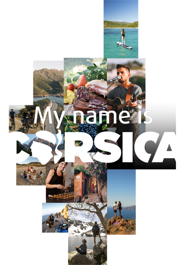
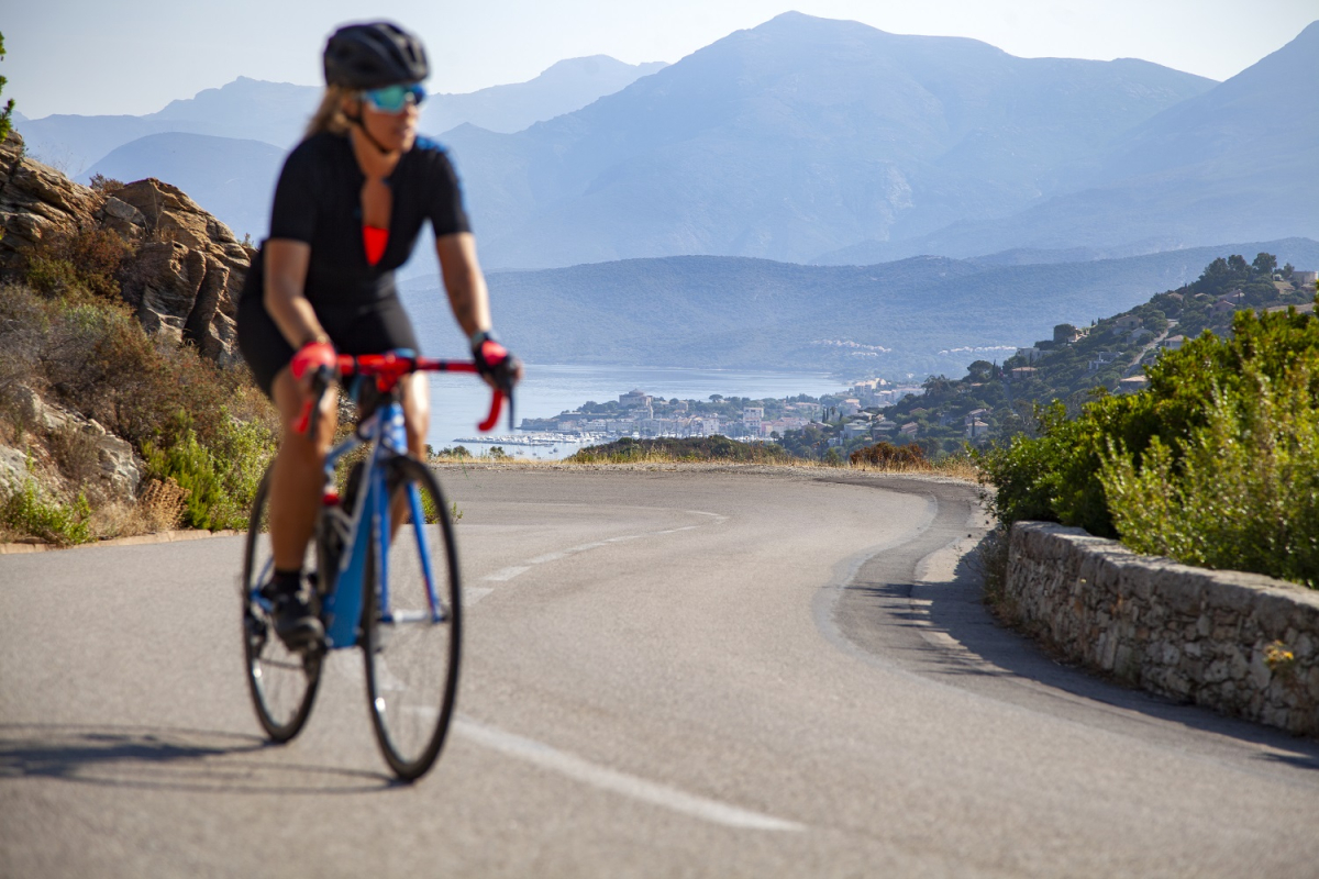
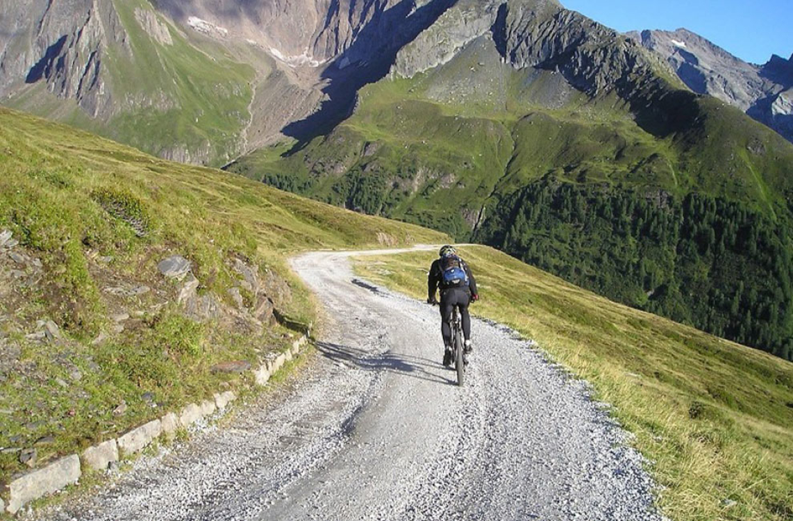
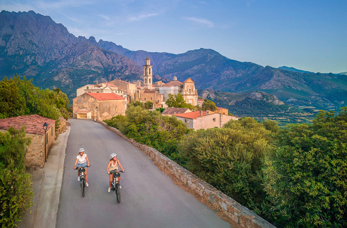
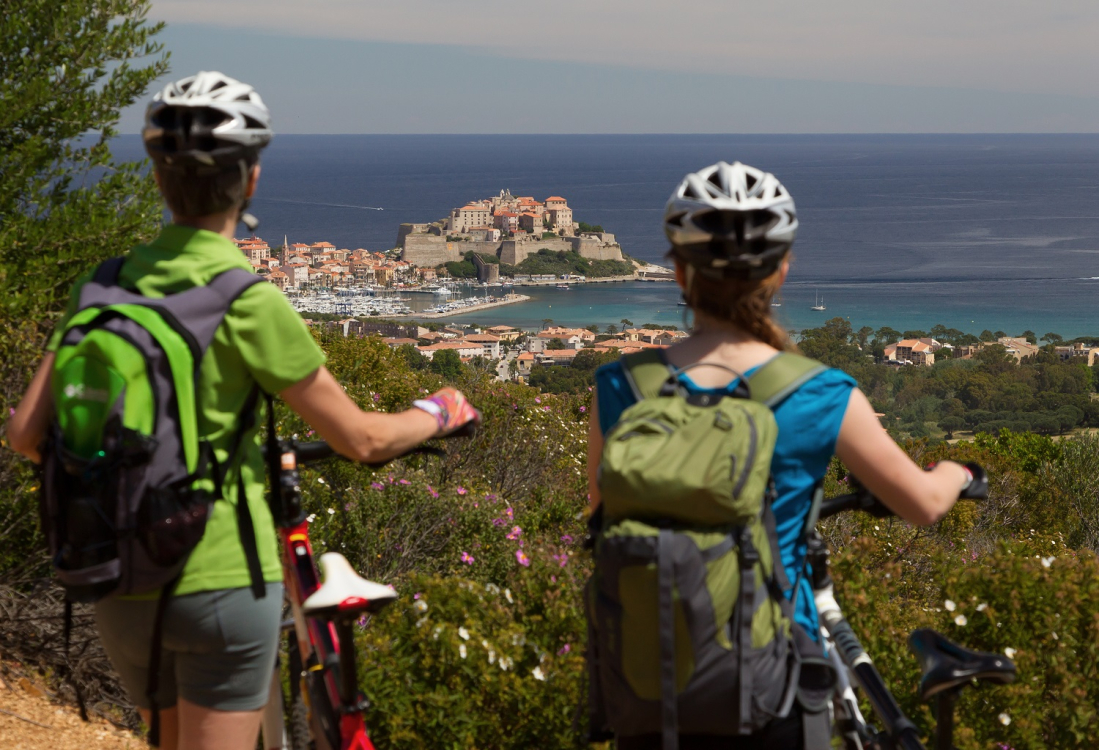
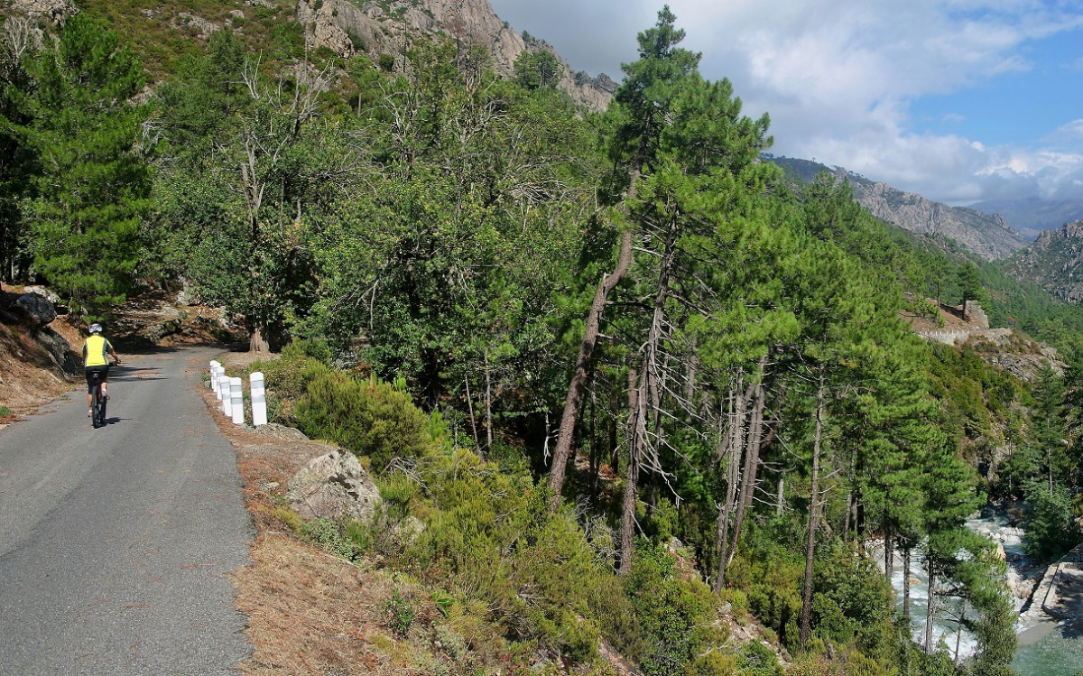
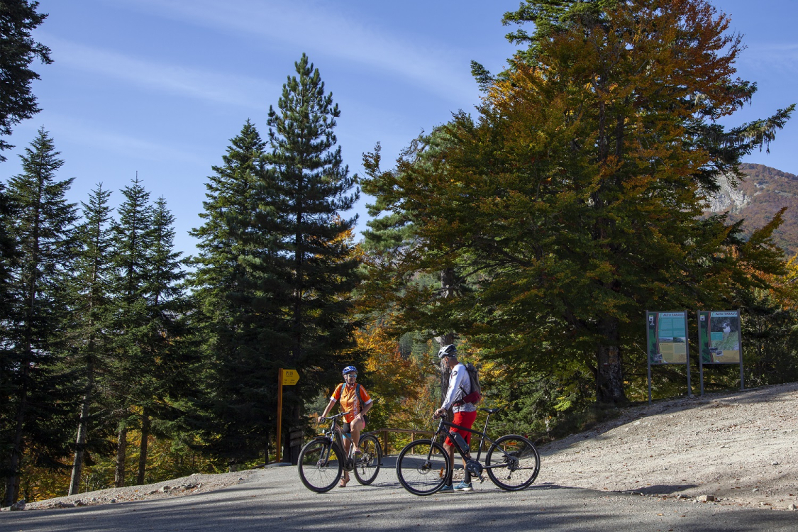
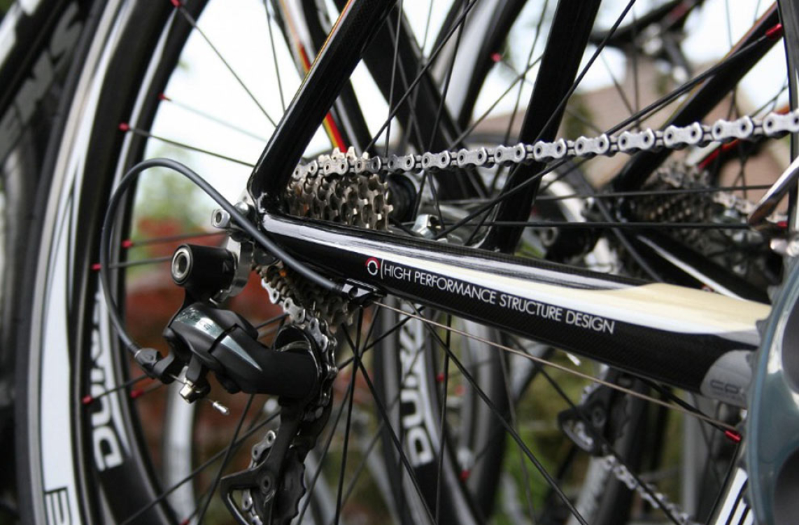
Cycle touring in Corsica includes mountain biking, gravel biking, and road biking
 ©ATC SYLVAIN ALESSANDRI
Here, the beauty of the region is not just a tourist attraction. Corsica offers cycling tours to suit all tastes: mountain bikers looking for thrills on technical trails, road cyclists attracted by challenging passes, gravel enthusiasts... This hybrid sport, accessible to all, allows you to escape on ancient paths, far from traffic and close to nature.
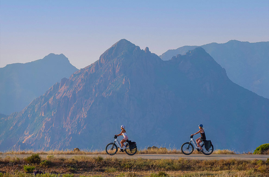
Versatile, gravel biking is attracting more and more enthusiasts looking for an authentic experience between the sea, scrubland and hilltop villages. Mountain biking is not to be outdone, with the French Cycling Federation (FFC) offering a wide selection of certified trails. Finally, the GT20 allows fans of long road trips to travel nearly 600 kilometers between Bastia and Bunifaziu (Bonifacio), revealing the rich diversity of Corsica's landscapes, from the coast to the mountains.
In addition to this wealth of routes, there is a range of accommodation designed for cyclists: hotels, gîtes, campsites, and guesthouses have developed specific services such as secure bike storage, repair shops, suitable catering, and personalized advice. Many establishments also display the “Accueil Vélo” label, which certifies a dedicated level of service and facilitates the welcome of travelers on two wheels.
In Corsica, cycle tourism is not just an outdoor activity: it is an invitation to discover an island full of character, to meet its inhabitants, and to enjoy its flavors and remarkable landscapes. Here, the routes offer beautiful escapes, and the stops along the way allow you to immerse yourself in a preserved culture and nature.
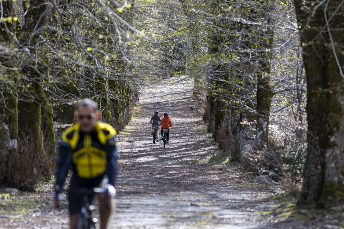
MTB loops: 5 FFC-certified trails
 ©ADOBE STOCK
Thanks to its network of loops certified by the French Cycling Federation (FFC), Corsica is now a national benchmark for mountain biking. It offers riders marked trails that are maintained and classified according to four levels of difficulty: green, blue, red, and black. With at least 100 kilometers of trails per site, each area has a welcome center with maps, information on the circuits, and bike maintenance equipment. Discover our five favorite loops, perfect for family getaways or trips with fellow enthusiasts.
Reginu mountain bike loop: authentic Balana at your fingertips
 ©Stéphane Compoint Onlyfrance
Imagine yourself in the heart of the Reginu plain, surrounded by golden fields, olive groves, and hills. Ideal for a family introduction to mountain biking, this 6 km loop, starting from the hamlet of Reginu, alternates between quiet roads, dirt tracks, and gently sloping single-track trails. The low elevation gain, with only 42 meters of climbing and 48 meters of descent, makes this ride accessible to all.
Classified as a Natura 2000 site, the Reginu plain is protected at the European level for its remarkable biodiversity. A true sample of Corsica's rural mosaic, it is home to the red kite, an emblematic bird of prey of the island. Between hills covered in scrubland, groves of holm oaks and fig tree hedges, biodiversity flourishes in this protected setting.
Algajola mountain bike loop: between land and sea in Balagne
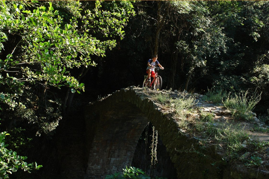
Starting from the village of Algajola, this moderate 6 km loop takes you along small paths winding through the Aregno plain, between open fields and Mediterranean vegetation. A few technical sections, particularly at the small bridge over the Aregno stream, add rhythm to the route and character to the ride.
The route offers a good balance between effort and reward. After cycling inland, the route crosses fields, orchards, and olive groves in the Aregno plain before winding through the fragrant scrubland between fig trees and holm oaks.
At the end of the loop, enjoy breathtaking views of the sea. It's the perfect opportunity to extend the experience with a refreshing break by the water, on the beach or on a terrace facing the blue Mediterranean.
Fiuminale mountain bike loop: in the heart of wild Corsica
For an adventure in the heart of wild Corsica, the Fiuminale loop is a 12-kilometer moderate route for mountain biking enthusiasts in search of authenticity. From Olmi-Cappella, the route passes through dense forests, runs alongside the typical villages of Vallica and Ghjunsani, and reveals spectacular views of the peaks, including Monte Cinto.
Along the way, the Tuani convent, a listed historical monument, offers a few rooms for an unusual stopover. With 282 meters of ascent and 274 meters of descent, this loop invites you to explore magnificent, unspoiled landscapes.
Mountain bike loop through vineyards and panoramic views
This 7-kilometer circuit, suitable for all, winds through the Corsican vineyards from Lumiu. On trails surrounded by vineyards and scrubland, the ride is perfect for families.
The route opens onto the sea and the citadel of Calvi, perfect for a photo break. With only 81 meters of elevation gain and 80 meters of descent, this loop combines pleasure, relaxation, and typical Balagne landscapes.
 ©lettas Fotolia
Spassiverde mountain bike loop: a coastal escape on the Costa Verde
This easy 6.4-kilometer route follows the coast between Prunete and Moriani, offering an accessible ride close to the beaches and sea air. The ride starts from the Padulella park car park, close to Moriani Beach. The route offers a family-friendly ride on flat paths, accompanied by the sea and the vast views of the Costa Verde.
The region offers a wide range of family-friendly accommodation, including hotels, apartments, and seaside campsites, so you can continue the fun after a refreshing bike ride.
Our other lesser-known mountain bike trails
Beyond the most famous trails, Balagne offers fifteen other loops totaling more than 200 kilometers of coastal paths and hilltop villages. The Castagniccia Mare è Monti region and the Costa Verde also have eleven trails and 124 kilometers of marked tracks that are accessible all year round. For a complete and varied overview, the VTOPO Corse guide lists fifty circuits suitable for all levels.
Before setting off, remember to check your equipment, follow the marked routes and consult the tourist offices for information on the condition of the trails. Helmets are compulsory for children under 12 and strongly recommended for everyone else, so that you can enjoy the diversity and quality of Corsica's trails in complete safety.
Gravel loops: pure adventure!
 ©ATC S.ALESSANDRI
Gravel is attracting more and more cyclists who are drawn to the freedom of riding on all types of terrain. Between forgotten roads, dirt tracks and forest trails, this hybrid practice allows you to venture far from traffic to explore the maquis, hilltop villages and wild panoramas of the island.
The gravel spirit in Corsica
Gravel is based on a simple philosophy: ride without constraints, explore alternative routes and prioritize discovery over performance.
Gravel is a slightly alternative way of cycling. It's not really about competition, it's more about discovery... Before, we used to call it hiking or cycle touring. Now, with the evolution of equipment and GPS systems, we can try to discover countries in a slightly different way.
- Xavier, rental agent & advisor at U Gattu -
Gravel bikes, which are based on road bikes but equipped with wider tires, are just as comfortable on asphalt as they are on gravel paths. This versatility allows you to set off independently, with bikepacking bags, for an adventure at your own pace, solo, with friends, or with family.
 ©lettas Fotolia
"The great thing about gravel bikes is that you can do whatever you want. There are no set rules... Gravel bikes are very comfortable and allow you to get off the road whenever you want. If you see a small path off to the side, you can take it. And you still have a bike that performs well on the road. "
|
Corsica is full of trails and small roads that are ideal for gravel biking. While the famous Gravel 20, which connects Bastia to Bunifaziu (Bonifacio), is still being studied and structured, the island already offers many inspiring routes. Crossing old, little-used roads, riding along farm tracks, venturing into forests or along the coastline make for a varied playground. Gravel biking is accessible to everyone, with no special technical skills required.
“It's super accessible. That's precisely what makes this type of cycling so appealing: accessibility above all else... It's not about performance, but rather comfort and being able to add accessories to your bike, known as bikepacking accessories. The idea is to set off on your bike with complete autonomy.”
|
Gravel routes: four exceptional loops to discover
 ©ADOBE STOCK
For enthusiasts eager to set off on the island's most beautiful routes, Corsica offers a wide range of adventures. From steep coastal paths to high-altitude plateaus, passing through scrubland and agricultural valleys, each route reveals a different facet of the territory. These four iconic loops offer unique experiences, suited to different levels and aspirations.
The Cap Corse Gravel Loop: a wild challenge between sea and cliffs
This route is one of the most spectacular in Corsica. It is reserved for cyclists seeking authenticity and challenge. The loop alternates between winding coastal roads, ridge trails, and cross-country paths, winding above the Mediterranean Sea. Ride along steep cliffs, pass through hilltop villages such as Nonza and Cinturi (Centuri), and enjoy breathtaking views of the sea, Genoese towers, and the maquis.
The wild atmosphere, the wind, the smell of the scrubland and the changing light accompany every turn of the pedals. The gravel tracks and steep gradients require a good level of fitness, but the reward is well worth it: total immersion in Cap Corse, between sea and mountains, far from the hustle and bustle.
The Agriate Gravel Loop: an adventure at the end of the world
The Agriate, a vast area of scrubland and white tracks, is an ideal adventure terrain for gravel biking. These tracks, typical of the region, are composed of light-colored earth, gravel, and sand. Their bright color under the sun offers a striking contrast to the dark vegetation of the scrubland.
The route often starts near San Fiurenzu (Saint-Florent) before heading off on sometimes sandy paths. Ride through unspoiled nature, without any buildings, until you reach the legendary Saleccia beach, famous for its white sand and turquoise waters. The isolation of the place, the raw beauty of the landscapes and the feeling of freedom make this loop a unique experience. Remember to bring water and something to repair a flat tire.
The Gravel Loop of the Cuscione Plateau: a pastoral escape at altitude
The Cuscione plateau in Alta Rocca offers an extraordinary loop between 1,400 and 1,600 meters above sea level. Cycle through vast natural mountain meadows dotted with alpine flowers, moss, and small shrubs. Then cross rivers, pass sheepfolds and be surprised by the presence of horses and pigs roaming free.
The trails alternate between rolling paths, forest passages, and stony trails, with panoramic views of the Bavella peaks and the Taravu Valley. The atmosphere is peaceful and wild, ideal for a getaway from it all in pastoral and unspoiled Corsica.
This gravel loop is reserved for experienced cyclists. As with all medium and high mountain routes, it is necessary to dress warmly and take the necessary precautions in case of mechanical problems.
The Reginu - Santa-Reparata-di-Balagna gravel loop: Balagna authenticity
Starting from L'isula (L'Île-Rousse), this 62-kilometer loop invites you to explore Balagne in a different way. The route alternates between secondary roads, farm tracks, and trails, crossing hills covered with scrubland, olive groves, and typical villages such as Santa-Reparata-di-Balagna and Monticellu.
Enjoy panoramic views of the Mediterranean and the mountains while discovering the region's rural heritage. This route, accessible to gravel enthusiasts, combines varied landscapes and authenticity for a total immersion in the Balagna spirit.
Practical tips and local resources
A few simple rules will ensure you enjoy gravel biking safely. Check your equipment, bring a repair kit, and check the weather forecast. Choose a bike to suit your ambitions: sturdy models for long-distance trips, lighter versions for performance-oriented outings.
 ©ADOBE STOCK
“Here, the idea is to take your time... You ride along at a leisurely pace, moving from one spot to another without any pressure to perform, and, best of all, with all your gear with you.”
|
To organize your adventure, call on local specialists who can offer expert advice, suitable equipment, and tailor-made packages. Whether you want to try it out for the first time or set off on your own, their knowledge of the area will prove invaluable.
 ©hassan bensliman adobe stock
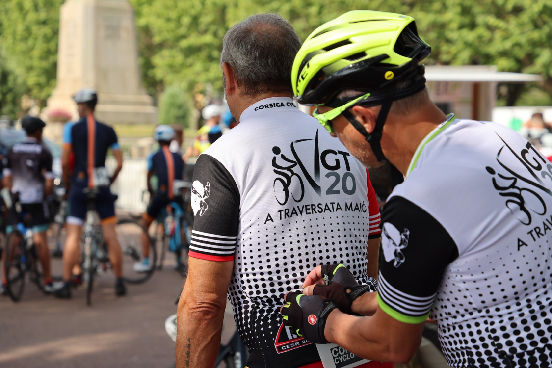
The GT 20: the ultimate road bike in Corsica
 ©ATC
©ATC
In the early morning, under the gaze of Napoleon wearing the attributes of Jupiter, the cyclist prepares to mount his bike and begin the great crossing of Corsica by bike. An adventure of nearly 600 kilometers, the first pages of which are written on the ochre asphalt of the Piazza Santu Niculà in Bastia. A few technical checks are necessary after a coffee on the terrace.
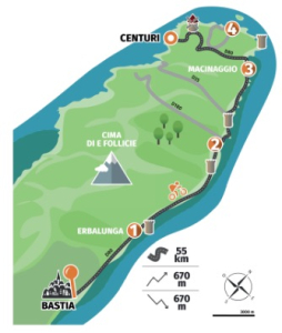
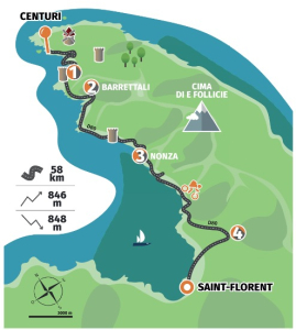
Stage 1 : From Bastia to Cinturi (Centuri)
Distance : 54 kms / Elevation gain : 676 m / Elevation loss : 676 m / Min. altitude : 0 m / Max. altitude : 361 m
Download the route here
The route leaves the hustle and bustle of the city behind and follows the departmental road towards the tip of Capicorsu (Cap Corse). The marinas and coves follow one after another until you cross the finger of Corsica from east to west.
The first kilometer runs alongside the port of Toga. Bastia recedes as you head towards Capicorsu (Cap Corse) and its coastline dotted with villages and rocky coves. Little by little, the traffic thins out and the view of the Tyrrhenian Sea opens up. Soon, the picturesque and iconic hamlet of Erbalunga comes into view.
Until U Macinaghju (Macinaggio), the road winds its way, promising some nice surprises for your legs, before turning sharply westward to climb higher and descend into a completely different world, that of a wilder, more rugged Capicorsu (Cap Corse), buffeted by the wind.
More information about stage 1 : https://www.visit-corsica.com/fr/Mon-sejour/Itineraires/Tous-les-itineraires/GT20-ETAPE-1-BASTIA-CENTURI
Tourist attractions to discover
- The unmissable marina of Brando, Erbalunga and its Genoese tower (breakfast)
- The small fishing port of Porticciolu and the Terra di Catoni vineyard opposite (wine tasting available)
- The port of U Macinaghju (Macinaggio) (lunch stop)
- The port of Cinturi (Centuri), renowned for its lobster fishing
- The tip of the cape: the architectural treasures of the eleven hamlets of the municipality of Ersa.
Variation on stage 1 :
The initial GT20 route can be varied to allow you to discover the itinerary in a different way. When you arrive at Botticella, in the municipality of Ersa, a beautiful 15-kilometer loop takes you to the tip of Cap Corse (Capicorsu) and allows you to visit the northernmost hamlets of the island, Barcaggiu and Tollari.
Some cycle tourists can also shorten their route by cutting across the Cap d'est from east to west without reaching U Macinaghju (Macinaggio).
Stage 2 : From Cinturi (Centuri) to San Fiurenzu (Saint-Florent)
Distance : 58 km / Elevation gain: 850 m / D -: 849 m / Min. altitude: 1 m / Max. altitude: 202 m
Download the route here
Heading south, the route continues along the coast, crossing completely wild areas and skirting villages and marinas. The route leaves the port of Cinturi (Centuri) and follows the coast before beginning the climb. A small road on the left leads to one of the oldest convents on the island, the Convent of the Annunziata. Soon, you will rejoin the D80, which winds along the western coast of Cap Corse. In Mursiglia (Morsiglia), the centuries-old vineyards are still in use and produce the unmissable Muscat du Cap wine.
The road winds and sometimes descends along sandy coves before climbing again to bypass the steepest areas of this wild coast. A cliff-lined road offering unique views of the sea, the Agriate and the mountain range.
It is impossible to see everything in a single day, so tourist stops should be carefully selected according to your tastes and desires. On the road, it is impossible not to notice a piece of the area's industrial history, the Canari asbestos mine. All around, the mountain has been scraped away and dug into steps to extract the mineral. To the south, the black beach of Nonza remains the most famous and is the perfect place to take a break. The route then slowly leads to the canton of Nebbiu and its wine-growing plains before running along the sea to the Genoese town of San Fiurenzu (Saint-Florent).
More information on stage 2 : https://www.visit-corsica.com/fr/La-destination-Corse/Inspirations-corses/Inspirations-deux-roues-et-GT-20/GT20-Etape-2-Centuri-San-Fiurenzu
Tourist attractions to discover
- The Patrimoniu (Patrimonio) vineyard, renowned among Corsica's PDO wines.
- The rum producer in Barrettali / Cap Corse citron
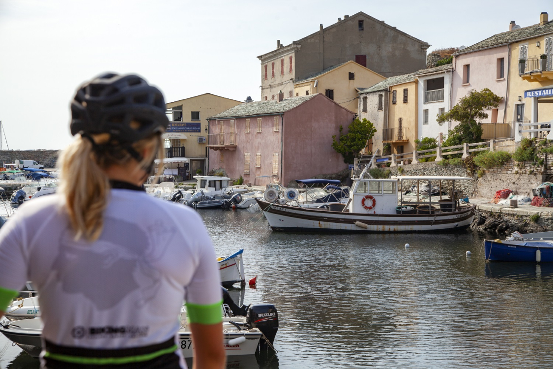
- The port of San Fiurenzu (Saint-Florent) in the shadow of the citadel and its lively streets
- The Grand Site of Conca d’Oru, Patrimonio vineyard – Gulf of Saint-Florent
Variation on stage 2 :
Leave the D80 and try the road through the hills towards Pinu (Pino) and the hamlets of Barrettali, then follow the D33 towards the Udine waterfalls and the Pendente mill until you reach the village of Canari.
 ©ATC S.ALESSANDRI
Stage 3: From San Fiurenzu (Saint-Florent) to Belgudè (Belgodère)
Distance : 61 km / Elevation gain: 1,181 m / Elevation loss: 885 m / Min. altitude: 0 m / Max. altitude: 686 m
Download the route here
You will quickly leave Capicorsu (Cap Corse) behind and head towards Agriate, where you will find a more inland, wilder side of Corsica with farmland occupied by herds and their herders. The first part of the route offers beautiful views of the Conca d'Oru and Nebbiu before branching off to the other side and returning to a wilder area, a desert of hills and small rocky mountains covered with low scrub. The hamlet of Casta soon appears, the gateway to the unmissable Saleccia beach. Still on the cliff top, the route climbs back up to the Col de Vezzu, the last viewpoint over the Gulf of San Fiurenzu (Saint-Florent) and the Agriate. On the descent, the sea disappears from view, giving way to a stretch of plains and vertiginous mountains, an inland Corsica that is more pastoral, where villages nestle on the hillsides.
You will need to cross Territorial Road 30 to resume the route towards Nuvella (Novella). The small road winds its way through farms and then joins the road to the Col de San Colombanu, the gateway to Balagne. From these heights, the view is breathtaking. Simply follow the asphalt road, still along the cliff edge, to discover the Balanin hinterland as far as the medieval village of Belgodère, perched like a balcony over the Reginu valley.
More information on stage 3 : https://www.visit-corsica.com/fr/La-destination-Corse/Inspirations-corses/Inspirations-deux-roues-et-GT-20/GT20-Etape-3-San-Fiurenzu-Belgude
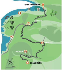
Tourist attractions to discover
- The secluded beaches of Saleccia and Ostriconi
- Farmhouse cheese producers around Nuvella (Novella), the village and the trinichellu (the corsican train) which still runs between Ponte-Leccia and L’isula (L’Île-Rousse).
- The medieval village of Palasca
Variation on stage 3 :
An alternative route allows you to follow the coast to Belgodère. Follow the Territorial Road 30 towards Calvi. This road takes you through the Col de Vezzu and the Agriate Desert. You can follow the Territorial Road 301 (the fastest route), or take the small Palasca road, the D363, which is narrower, more picturesque, but busier with cars.
(It would be interesting to mention the loop that takes you down the San Colombanu descent, to Ghjunsani (Giussani) and the famous Col de Battaglia before plunging down to Speloncatu).
There is another option, a 25 km loop with a 700-meter elevation gain, which connects the descent from San Colombanu, Ghjunsani, and the famous Battaglia Pass before plunging down to Speloncatu. At the top of the San Colombanu climb, just after the San Colombanu ridge (∼360 m), where the pass drops down towards the coast, take the small D62 road that heads inland (do not continue south on the D81). You will arrive at a very rolling false flat (2–3%) for 3 km, through scrubland and chestnut groves. Pass the quiet little village of Ghjunsani to reach the climb up to the Col de Battaglia, continuing on the D62. The gradient is moderate at 5–6%, but in places you will encounter some steep sections at 8 or 10%.. The superb Corsican beech forests and the few views of the Balagne plain to the west will make you forget the 7 km climb and 350 m elevation gain. You then descend to Speloncatu with a 10 km descent of tight bends on a narrow but well-maintained asphalt road. Then follow the D62/D263 for 5 km to reach the confluence of the Golo, at an altitude of 200 m, 7 km from Belgudè (Belgodère).
Stage 4 : From Belgudè (Belgodère) to Calinzana (Calenzana)
Distance: 43 km / Elevation gain: 463 m / Elevation loss: 494 m / Min. altitude: 221 m / Max. altitude: 531 m
Download the route here
The gateway to the Balanin hinterland, this mountain road is a cornice offering incredible panoramic views. From village to village, the route winds along the steep slopes of the mountains, allowing cyclists to enjoy exceptional views of green valleys that inevitably lead to turquoise beaches. Throughout the route, remarkable buildings catch the eye. The road passes through the towns, but often without going through the center. Accessing them requires a little extra effort, a curiosity that leads to the discovery of rich and typical lifestyles and architecture in the Balanin hinterland.
This fourth stage of the journey is therefore a visit to meet the people of Balagne and discover where they live. It is a search for hidden corners and places that will leave you with incredible memories. Dare to venture forth with an open mind and you will learn more about Corsica. There are many treasures to discover until the end of this walk in Calenzana, the starting point of another world-famous route, the GR20®.
More information on stage 4 : https://www.visit-corsica.com/fr/La-destination-Corse/Inspirations-corses/Inspirations-deux-roues-et-GT-20/GT20-Etape-4-Belgude-Calinzana
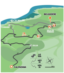
Tourist attractions to discover
- Costa and its heritage, notably the Church of Saint-Sauveur
- An exceptional charcuterie in Ville-di-Paraso
- The last traditional oil mills in Feliceto
Variation on stage 4:
This fourth stage follows the D71 from Belgudè (Belgodère) to Calenzana. If you follow the route carefully, this cliff-top road skirts the villages without passing through them or revealing their heart and soul. In each village, in just a few minutes and with very little additional elevation gain, you can discover centuries-old places of life. Leaving Belgodère, you can head towards the plain via the Belgudè train station (Belgodère) and follow the D113 towards the lake and Codole dam. From there, you can climb back up to Muru or continue towards Santa-Reparata di Balagna, then Curbara and climb back up to the cliff road via Pigna, skirting the famous Sant'Antoninu promontory with its breathtaking views and famous lemons.
Stage 5 : From Calinzana (Calenzana) to Galeria
Distance: 31 km / Elevation gain: 412 m / Elevation loss: 676 m / Min. altitude: 6 m / Max. altitude: 430 m
Download the route here
You are now entering a bucolic stage, where green pastures give way to an ever-changing valley. The last hikers set off for the peaks of the GR20®, while you, on your bikes, take the D51 towards Galeria. The road descends gently, skirting hills and streams until it reaches the Figarella bridge and the edge of the Bonifatu forest. Under the proud gaze of the Finocchiaghja ridge, you climb again to reach the Marsulinu pass and descend into the valley of the same name.
Winding its way up the hillside, the road takes you to farmland where niulinchi once grazed. Fragrant with aromatic herbs, this stretch along the stream invites you to slow down and breathe in the unique scent.
Finally, the road takes you back to the Fangu plain and the legendary five-arch bridge. Here, UNESCO has been watching over huge thousand-year-old oak trees since 1977, while the Paglia Orba peak and the Tafunatu eye stand like stone sentinels. Just a few more pedal strokes and you'll reach Galeria and its picturesque port!
More information about stage 5 : https://www.visit-corsica.com/fr/La-destination-Corse/Inspirations-corses/Inspirations-deux-roues-et-GT-20/GT20-Etape-5-Calinzana-Galeria
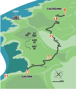
Tourist attractions to discover
- The soap maker at the Barbosa house in the village of Calenzana
- The U Marsulinu farm with its sheep's cheese, organic beef, essential oils, and aromatic plants.
- The mineral gem of Scandula Nature Reserve,a Unesco Wolrd Heritage Site, by boat from Portu (Porto) or Galeria for more intimate excursions
- A must-do swim at Ponte Vecchiu and a tasting of fresh produce at the Chjarasgiu hut near the village of Manso
Variation on stage 5 :
It's hard to find an alternative route to the one already suggested by the GT20 trail. This is an opportunity to stray from the beaten track and explore the surrounding area. If you have followed the route via the Marsolinu pass towards Galeria, there is only one road you can take. However, just after GAEC Marsolinu, a small departmental road (D351b) climbs up to the left, towards Bocca di Nuvella and the church of Santa Lucia in Galeria.
Further down the valley, once you reach the Cinque Arcate bridge, you can choose to head towards Calvi to reach Crovani Bay, the old Argentella mine, and the small dam next to it. Another option is to cross the bridge and head towards the village of Manso, following the Fangu River.
Stage 6 : From Galeria to Portu (Porto)
Distance: 50 km / Elevation gain: 722 m / Elevation loss: 697 m / Min. altitude: 5 m / Max. altitude: 402 m
Download the route here
After leaving the mysterious waters of the Fango, the climb continues without respite. Once at the pass, you will be immersed in a wild and magnificent part of Corsica. First, you follow the left bank of the Fangu before turning inland.
The Col de Palmarella takes you into Balagne and western Corsica, a land of low scrub where ochre volcanic rocks plunge into a deep blue sea. Ahead of you, Cap Seninu rises up, a majestic remnant of an ancient volcano.
The road, faithful to the rugged terrain, winds its way through a series of bends and breathtaking panoramas: watch out for herds of goats that sometimes appear around a bend! This section offers a unique setting, contrasting with the previous stages.
At Bocca a Croce, the village of Osani comes into view, while the Gulf of Portu (Porto) stretches as far as the eye can see. The coastline reveals itself in coves and beaches, but beware: one last effort is required! After Curzu and its picturesque hamlet, you cross Partinellu, rich in turbulent history, then follow steep cliffs to Serriera before descending to the charming port of Porto.
More information about stage 6 : https://www.visit-corsica.com/fr/La-destination-Corse/Inspirations-corses/Inspirations-deux-roues-et-GT-20/GT20-Etape-6-Galeria-Portu
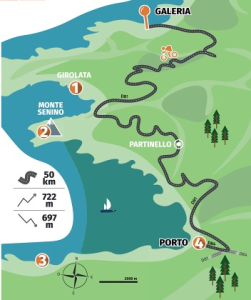
Tourist attractions to discover
- The fishing village of Girolata and its 16th-century fort, which has been recently restored
- The hike to the summit of Seninu, Europe's highest sea cape, at an altitude of 618 meters
- The unmissable ochre rock cathedral of Calanche di Piana, which can be explored by bike or on foot.
Variation of stage 6 :
From Galeria, follow the Fangu River towards the village of Manso and venture into a wild and unspoilt valley. Continue along the track to the old convent of Santa Maria for a magnificent view of the source of the Fangu. Beautiful pools offer the opportunity to take a dip in the admittedly a little cool, but crystal clear and invigorating.
It is impossible not to follow the D81 road to reach Porto. On the way, after Bocca à Croce, the route passes through three villages, Osani, Partinellu and Serriera. All three boast coves and secluded, wild beaches (Gradelle, Caspiu and Bussaghia).
 ©Stéphane Compoint Onlyfrance
Stage 7 : From Portu (Porto) to Verghju
Distance: 33 km / Elevation gain: 1,478 m / Elevation loss: 45 m / Min. altitude: 32 m / Max. altitude: 1,476 m
Download the route here
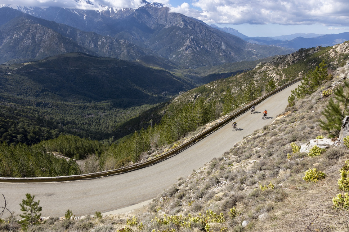
You are now facing an exceptional stage: the legendary polka dot jersey is up for grabs! From Porto, you will climb more than 1,400 m to Notre-Dame-Des-Neiges, at the Col de Verghju. It's not so much the gradient as the length – over 30 km without a single flat section – that will put your calves to the test.
But keep your eyes peeled: the road, carved out of the cliff face, first follows the Portu (Porto) river before opening up onto the Spelunca Gorges, a spectacular sight that is well worth a few stops to catch your breath.
The climb is punctuated by stops in typical villages: Evisa, nestled among chestnut and laricci pine trees, marks the transition to a pine forest where amazing natural pools nestle.
As the kilometers pass, the temperature drops with every meter climbed; herds and shade alternate, and the old cross-country ski resort reminds you that, from the coast to the snow-capped peaks, Corsica unfolds all its magic along the same route.
More information about stage 7 : https://www.visit-corsica.com/fr/La-destination-Corse/Inspirations-corses/Inspirations-deux-roues-et-GT-20/GT20-Etape-7-Portu-Verghju
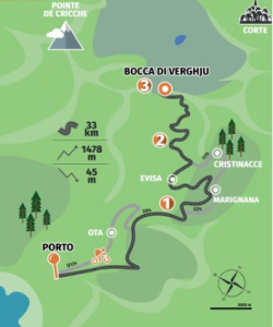
Tourist attractions to discover
- The crystal-clear natural pools of A Madre, the cliffs of Scalella and the Valla Scarpa waterfall
- The Genoese bridge of Zaglia in the Spelunca Gorges
- The magnificent sheepfolds of E Radule, a few minutes from the Vergio Pass
The GT20 route follows the D84 to the Verghju Pass. However, you can turn off at Portu (Porto) and head towards Ota on the D124.
After passing under the Santa Lucia chapel, the road crosses the village to rejoin the official route.
A little further on, you can make the same choice again, without extending the stage too much, to discover Marignana, a village founded by niolinchi in the 15th century. The houses, with their interesting architecture, are organized around the parish church of Saint-Jacques.
From there, you can rejoin the normal route to Evisa, or extend the walk a little further to discover Cristinacce, another mountain village.
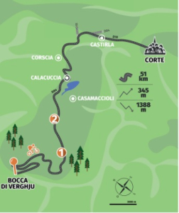
Stage 8 : From Verghju to Corti (Corte)
Distance: 51 km / Elevation gain: 345 m / Elevation loss: 1,388 m / Min. altitude: 350 m / Max. altitude: 1,477 m
Download the road here
This eighth stage will take you from the peaks to the citadel. At the start, you are already at an altitude of over 1,400 m, where the Col de Verghju nestles under the pine trees of Valdu Niellu. The road winds its way through tight bends, sometimes in a horseshoe shape, taking you out of the forest and into Casamaccioli and then Albertacce, where ranches dot the valley.
Before you lies Lake Calacuccia, a peaceful mirror reflecting the mountains and clouds. Drive through the picturesque village beneath the bell tower of the Church of Saints Peter and Paul, then let yourself be captivated by the legendary Scala di Santa Regina: a narrow granite gorge where the Golu river roars, the natural guardian of Niolu.
Until the Castirla bridge, the road winds its way through the rocks and ancient fortifications before climbing up to the less frequented high corniche that will take you to Corte. And there, perched on its spur, the Eagle's Nest—a remnant of the citadel—awaits you to conclude this alpine adventure.
More information about stage 8 : https://www.visit-corsica.com/fr/La-destination-Corse/Inspirations-corses/Inspirations-deux-roues-et-GT-20/GT20-Etape-8-Verghju-Corti
Tourist attractions to discover
- The Valdu Niellu tree-top adventure park in the middle of the laricci pine forest
- Horseback riding to Lake Nino to discover forgotten sheepfolds
- The Casanova bakery and its traditional pastries in Corte
Variation on stage 8 :
For once, changing your itinerary on this stage means getting closer to the heart of the villages that line the D84. Casamaccioli hosts the A Santa di u Niolu procession in September. You can continue along the road and reach the Calacuccia dam via the south-eastern shore of the lake, or return to the classic route and head to Lozzi, the highest village on the island. (From Lozzi, a walking route takes you to Monte Cintu, the highest point on the island at 2,706 meters above sea level). At the entrance to the Scala di Santa Regina is the road leading to Corscia, a village rich in an agropastoral culture that is still very much alive, with many sheepfolds still in use in the municipality, some of which are examples of traditional architecture.
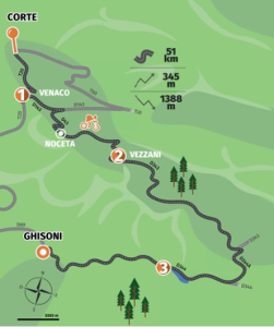
Stage 9 : From Corti (Corte) to Ghisoni
Distance: 58 km / Elevation gain: 1,354 m / Elevation loss: 1,136 m / Min. altitude: 248 m / Max. altitude: 808 m
Download the route here
The ninth stage of the GT20 promises sublime landscapes and thrills. It starts in the heart of the island's main axis before branching off onto a charming little road that passes through inland villages and the legendary Col de Croce.
As soon as you leave Corti (Corte), you will climb a little to admire the panoramic view of the capital of central Corsica, then rejoin the T20. Be careful of traffic: the road is not the most welcoming for cycle tourists. You will quickly reach Venaco, where the Tavignano river offers superb panoramic views.
You will then turn towards Aleria and begin a refreshing, shaded descent to the Nuceta bridge. This is where the climb up the Col de Croce begins: a 600-meter climb on a quiet, leafy D43 road, dotted with the villages of Nuceta (Noceta) and Ruspigliani (Rospigliani).
At the top, enjoy the view before diving down for ten kilometers towards Vezzani and Pietroso, where Corsican rural life welcomes you. Don't miss the turn-off onto the D344a to climb the small Col de Cardu: it will take you to the spectacular Inzecca gorge, a canyon carved out by the Fium'Orbu river, which ends at the Sampolu dam and tunnel.
Finally, the last section takes you to Ghisoni, overlooking the lake and its lush forests, offering a grandiose setting worthy of tropical regions.
More information about stage 9 : https://www.visit-corsica.com/fr/La-destination-Corse/Inspirations-corses/Inspirations-deux-roues-et-GT-20/GT20-Etape-9-Corti-Ghisoni
Tourist attractions to discover
- A family-friendly lunch break at the Sampolo farmhouse inn in Ghisoni
- A stop in the hamlets of Venaco below Punta di Raffe
- Some shopping at Paul Fanti's « La Vezzanaise »
- A breath of fresh air on the banks of the Fium'orbu dam
Variation on the stage 9 :
This stage mainly follows the route between the parishes of Vivariu and Castellu, but there are several alternatives:
The Corniche Road (T20)
Stay on the T20 after Venaco to climb the Vecchiu valley and cross the viaduct of the same name, often mistakenly attributed to Gustave Eiffel. This will take you to Vivariu. From there, you can cut directly to Vezzani to rejoin the main route, or continue on the T20 to the ruins of the Pasciolu fort before tackling the spectacular Col de Sorba, which is demanding but magnificent.
The Tavignanu Gorges
From Corte, take the T50 (or from Riventosa via the D40) to plunge into the heart of the wild Tavignano Gorges. To avoid adding too much to your journey, join the D143 towards Nuceta (Noceta), or, if you feel like it, make a detour to the charming chapel of San Giovanni and its Genoese bridge before returning to the D143.
 ©ATC S.ALESSANDRI
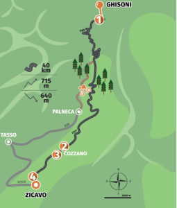
Stage 10 : From Ghisoni to Zicavu (Zicavo)
Distance: 39 kms / Elevation gain: 721 m / Elevation loss: 646 m / Min. altitude: 653 m / Max. altitude: 1,294 m
Download the route here
With the granite peaks of Éleison as a backdrop, the start of stage 10 takes you into the Marmanu forest. You will cross the border into southern Corsica, heading towards the Col de Verde for a 640 m climb.
On this shaded road, you will navigate a series of tight bends and enjoy views of the Fium'Orbu and its many bridges before the final hairpin bends (demanding on the thighs) take you to an altitude of 1,289 m.
You will then enter the Taravu Valley, renowned for its pig farming and its “wild river.” The descent is a welcome relief, but should be approached with caution (the pigs like to lie in the sun at the side of the road!), and offers glimpses of magnificent panoramas. Soon, the church of Cozzano comes into view, nestled in the heart of the village, before you begin the last wooded section to Zicavu, perched on the pastoral plateau of Cuscionu.
More information about stage 10 : https://www.visit-corsica.com/fr/La-destination-Corse/Inspirations-corses/Inspirations-deux-roues-et-GT-20/GT20-Etape-10-Ghisoni-Zicavu
Tourist attractions to discover
- Saffron and honey producers in Cozzano
- Enjoy a good beer at the Monte Kyrie Eleison Brewery in Ghisoni
- The local museum tracing the history of the link between the island and its pigs, a "nustrale" breed in the village of Cozzano
- The good family restaurant Florida at the hotel-restaurant and the Pacific Sud in Zicavu
Variation on stage 10 :
At the Verde Pass, for those traveling by gravel bike or mountain bike, set off to explore the villages on the west bank of the Taravo: first Palneca, stronghold of the formidable Joseph Bartoli, then a forest track will take you north to Ciamannacce, where stone houses with tiled roofs form a charming ensemble.
The next stop is Sampolu, where some of the facades still bear inscriptions from the 18th century, a beautiful reminder of the restructuring that took place at the time. You can then head towards Tasso via the D128 to admire “A Tola di u Piccatu” - the legendary “table of sin” - and its mysterious atmosphere, before discovering a carved wooden Christ in the spire of the church of San Giacomo. Finally, head to the hamlet of Giovicacce, then climb gently back up to Zicavu (Zicavo) via the D753a.
In Zicavu (Zicavo), E-Bike Mountain offers electric bike rentals to follow the forest trails of a unique place in the Corsican mountains, the Cuscionu plateau. A haven of peace for free-roaming animals, hikers, and cyclists.
 ©ATC S.ALESSANDRI
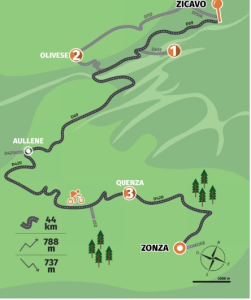
Stage 11 : From Zicavu (Zicavo) to Zonza
Distance: 44 km / Elevation gain: 788 m / Elevation loss: 737 m / Min. altitude: 669 m / Max. altitude: 1,195 m
Download the route here
The 11th stage starts at first light to take advantage of the cool temperatures, as the road immediately climbs for fifteen kilometers to the Col de la Vaccia (1,195 m), the junction between Taravo and Alta Rocca. Look up to admire the rugged terrain and the “wild river” valley you are leaving behind.
At the top, the panorama changes dramatically: wild landscapes, ochre ridges and jagged rocks make up a raw and grandiose natural landscape. The descent to Auddè (Aullène) is a treat: perfect curves and breathtaking views all the way to Serra-di-Scopamène, a nest perched high up where hikers on the Mare a Mare Sud trail stop for a rest.
Following the D420, you will pass the Sorbollano junction towards Quenza: your gaze will naturally be drawn to the Bavella peaks, red granite cathedrals.
After returning to the Cuscionu plateau, don't miss the Tuscan castle on the outskirts of Quenza. Refresh yourself at the Cavadili stream, then make one last push towards Zonza: this Mediterranean-style village, nestled between the sea and the mountains, will be your reward after this epic eleventh stage of the GT20.
More information about stage 11 : https://www.visit-corsica.com/fr/La-destination-Corse/Inspirations-corses/Inspirations-deux-roues-et-GT-20/GT20-Etape-11-Zicavu-Zonza
Tourist attractions to discover
- Jacques Zecchi's restaurant in Stadda where he cooks his dishes standing up in pizza ovens
- The Bergerie of Bassetta restaurant in Zicavu (Zicavo) a stone's throw from the Cuscionu plateau (one of Corsica's must-see sites)
- The Fiori di Paesi grocery store in the village of Olivese with a selection of farm products and charcuterie produced in the municipality
- Vannina Recco's PDO chestnut honey from the heights of Quenza
- The imposing peaks of Bavella, the last great rock barrier of the Corsican mountains.
Variation on stage 11 :
By choosing to follow the Taravo River, you are opting for a more challenging detour... but one that is well worth the effort! Leave Zicavu (Zicavo) heading west, follow the river and admire the spectacular climbing wall on the road to Vergaju. Shortly after, cross the Mulinelli bridge to reach Guitera-les-Bains: a remnant of its glorious thermal past, a sulfuric pool still welcomes you.
Continue along the D757 through the gorges carved out by the Taravo, where rock and water have been battling for centuries. Overlooking the river, the road leads you to Olivese, a village of artisans and farmers.
From there, you have two options:
- Join the main route via the charming, narrow and peaceful D26.
- Or continue on the D757 to Moca, climb the splendid Col Saint-Eustache, then descend to Auddè (Aullène). This will add some elevation, but will transform this section into a real bonus stage before returning to the road to Zonza.
 ©ATC S.ALESSANDRI
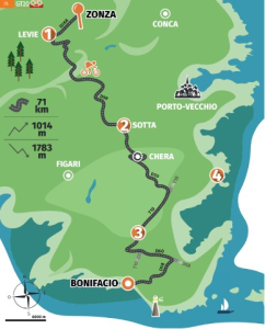
Stage 12 : From Zonza to Bunifaziu (Bonifacio)
Distance: 71 kms / Elevation gain: 1,014 m / Elevation loss: 1,783 m / Min. altitude: 5 m / Max. altitude: 805 m
Download the route here
From Alta Rocca to the limestone cliffs, this final day is full of surprises.
In the heart of the pine trees on the D268, you will witness the first rays of sunlight on the orange-tinged peaks of Bavella.
This shaded section passes smoothly to San-Gavinu-di-Carbini, then on to Levie. Stay alert so you don't miss the fork to the D59, the starting point for a long descent of nearly 1,800 m.
The road takes you to Carbini, where the isolated bell tower and orientation table mark the start of a sustained descent. Then get ready to climb up to 809 m at the Col de Bacinu: a natural gateway to the far south.
The descent to Usciolu is spectacular, with views of the Cagna massif, Porto-Vecchio and, on a clear day, Sardinia. Ride to Sotta, then climb up the coast to the hamlet of Chera, rich in archaeological remains.
From the D59, join the T10 and follow it to the Sant'Amanza junction. Here, the Bonifacio plateau comes into view, suspended above the turquoise waters. Finally, the majestic silhouette of Bunifaziu (Bonifacio) appears: your triumphant arrival at the end of this unforgettable GT20.
More information about stage 12 : https://www.visit-corsica.com/fr/La-destination-Corse/Inspirations-corses/Inspirations-deux-roues-et-GT-20/GT20-Etape-12-Zonza-Bunifaziu
Tourist attractions to discover
- The archaeological site of Cucuruzzu and the museum in Levie dedicated to Neolithic and Bronze Age archaeology
- The vineyards of the Domaine de Zuria and its remarkable cellar
- The sandy beaches and turquoise waters near Bunifaziu (Bonifacio) and Lavezzi
- The beach and the chasm near the Pertusatu lighthouse and its sea cave
Variation on stage 12 :
Rather than heading straight to Levie, take a detour to Porto-Vecchio without adding to your day. Take the D368, and the climb through the Zonza forest will take you to the Col d'Illarata (988 m), before a gentle descent to Piscia di Gallu: a breathtaking 80 m waterfall that is not to be missed. Further down, let yourself be charmed by Lake Ospedale and its dam, where you'll find a tree-top adventure park and a spectacular zip line offering breathtaking views of the extreme south. Then head back down to Porto-Vecchio to stroll through the old town, then take the T10 to Bunifaziu (Bonifacio) to rejoin the main route.
(not great cycling from Porto Vecchio to Bonifacio)
If you want to avoid a large part of the T10 road, you can also take the D859 for 8 km towards Pinarellu, then the D438 towards Sainte-Lucie for 4 km, which is very easy to ride, and finally the slight incline of the D459 for 6 km towards Lecci. You will then only have 10 km of the T10 left to reach Bunifaziu (Bonifacio). This alternative avoids a busy road in favor of sea views, fragrant scrubland, and isolated chapels.
How to prepare for the GT20: our tips and advice
 ©ADOBE STOCK
The GT20 is a unique cycling adventure across Corsica. The route from Bastia to Bunifaziu (Bonifacio) can be completed in its entirety or in sections. Careful preparation is essential to get the most out of this unique experience.
Choose the ideal time of year
The period from April to mid-July offers mild temperatures and less busy roads. The days are getting longer, nature is coming back to life and the mountain passes are once again passable. It's the perfect time to enjoy the unobstructed views and the cool morning air.
The late season, in September and October, also guarantees good conditions with the added bonus of plenty of sunshine and mild temperatures. There are fewer tourists and the atmosphere becomes more authentic. The autumn colors of the maquis offer a magnificent spectacle, especially at high altitudes.
Avoid July and August, when the heat is intense in some valleys and on exposed roads. Temperatures regularly exceed 35°C.
 ©Stéphane Compoint Onlyfrance
Organize your accommodation and logistics
For a peaceful experience, choose “Accueil Vélo” establishments. This national label guarantees dedicated services: secure bike storage, repair kits, electric charging, route advice, laundry, energy-packed breakfasts, and luggage transfer. Camping appeals to those who love freedom. Check with the tourist offices. It is regulated or prohibited in some municipalities. For those who prefer comfort, Corsica offers a wide range of accommodation: hotels, gîtes, campsites, bed and breakfasts, and homestays. Don't forget to book, especially in isolated villages where accommodation is limited. From Porto onwards, campsites become scarce: opt for bed and breakfasts or hotels.
For transporting bikes and luggage, renting a utility vehicle is a practical option. Some agencies, such as Leclerc, offer transfers throughout the island at attractive rates.
Preparing your equipment
 ©ADOBE STOCK
The diversity of Corsica's terrain requires a sturdy bike. You can use your own equipment or hire it on the island. From muscle-powered bikes to electric bikes, there is something for everyone.
Bring versatile clothing: although the first stages take place in a mild climate, the mountains can sometimes hold surprises. Cold, wind, and rain can take you by surprise when crossing passes at over 1,000 meters. A windbreaker or waterproof jacket is essential. Don't forget a repair kit, basic tools, and something to drink.
***
Set off to explore the riches of Corsica by bike. The Isle of Beauty offers a good balance between effort and contemplation. Each outing becomes an intimate exploration of the territory, far from the hustle and bustle of the classic tourist circuits.
As the kilometers go by, the landscapes change. Between imposing mountains, green valleys, secret beaches, perched villages, and forests with vertiginous passes, Corsica reveals its many faces. Beyond its landscapes, the island's soul leaves a deep impression on travelers. In this land of traditions, hospitality transforms stops along the way into genuine encounters. Establishments with the “Accueil Vélo” label perfectly embody this spirit: tailor-made services, expert advice, and special attention to the needs of cyclists naturally enrich the stay.
The island has something for everyone. Thrill seekers can hurtle down steep trails on mountain bikes. Gravel enthusiasts can enjoy the freedom of wild trails. Road cyclists can take on the challenge of the legendary passes of the GT20. Everyone can tailor their adventure to their desires and ability.
Tempted by adventure? Corsica offers cyclists a unique setting where effort is rewarded with unforgettable panoramas. Between sporting challenges and moments of contemplation, every outing promises a rich and memorable experience.